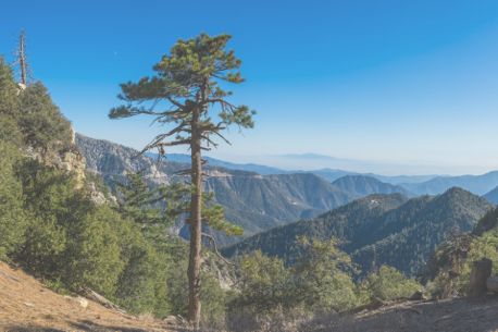
Experience the beauty of Nantahala National Forest RV camping in North Carolina's largest forest, spanning 531,000 acres of stunning landscapes. Perfect for outdoor enthusiasts, the forest features lush trails, cascading waterfalls, serene lakes, and exciting activities like rafting on the Nantahala River. Popular seasons include fall for vibrant foliage and spring for blooming wildflowers.
Camping near Nantahala National Forest offers options for all preferences. Stay at campgrounds like Standing Indian, near the Appalachian Trail, or Tsali Recreation Area, a favorite among mountain bikers. For a budget-friendly experience, enjoy free dispersed camping along Forest Service roads such as Wine Spring Bald. Explore various RV-friendly campgrounds near Nantahala National Forest, which offer amenities like full hookups. You can also look for rentals in RVShare for your trip.
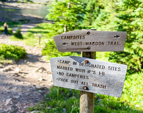
Camping in Nantahala National Forest
Nantahala National Forest offers a variety of camping options catering to different preferences and budgets. Don't forget to check out the top campgrounds in North Carolina. With RVshare, you can ensure a smooth and hassle-free RV experience by locating the best RV dump stations nearby.
Best Campgrounds in Nantahala National Forest
$20-$40 per night
$20-$25 per night
$15 per night
$20-$40 per night
Campgrounds Near Lakes, Waterfalls, and Rivers
$20 per night
Price not mentioned.
$30 per night
$35-$49 per night
$24 per night
Price not mentioned.
Appalachian Trail Dispersed Camping
Joyce Kilmer Road NCSR #1134
Blue Valley Dispersed Camping
Ellicott Rock Wilderness
Snowbird Creek
Ammons Branch Campground
Private Campgrounds Nearby
$50-$65 per night
$80-$110 per night
$55-$75 per night
Group Camping Areas
Price: $75-$150 per night
Capacity: Up to 25-50 people.
Price: $75 per night
Capacity: Up to 75 people.
Price: $75 per night
Capacity: Up to 25 people.
Nantahala National Forest Hiking Trails
Nantahala National Forest features diverse hiking trails for all skill levels, from easy walks to challenging treks. Below is a list of notable trails, including their lengths and difficulty levels.
Easy Trails
Length: 2 miles
Difficulty: Easy
Length: 1 miles
Difficulty: Easy
Length: 2 miles
Difficulty: Easy
Moderate Trails
Length: 2 miles
Difficulty: Moderate
Length: 6.5 miles
Difficulty: Moderate
Length: 1 mile
Difficulty: Moderate
Challenging Trails
Length: 2.5 miles
Difficulty: Challenging
Length: 29 miles
Difficulty: Challenging
Length: 9.8 miles
Difficulty: Challenging
-
Cable Cove Nature Trail #58
Cable Cove Nature Trail #58 is an easy one-mile loop trail that offers excellent opportunities for bird-watching and spotting wildflowers. There is even a small waterfall near the end of the hike.
Length: 1 mile
Intensity: Easy
-
Cheoah Trail #407
Cheoah Trail #407 begins near the U.S. Forest District Office. Historical markers on the trail offer visitors information about the Civilian Conservation Camp that once occupied the area. The trail winds through the forest, allowing glimpses of Santeetlah Lake through the trees.
Length: 2.5 miles
Intensity: Easy
-
Hooper Bald Trail #60
This short and easy trail is perfect for those who want to enjoy the scenery without a rugged hike. The path starts at a paved parking area and leads visitors to Hooper Bald. At an elevation of 5,500 feet, the Bald is one of the highest points in the county.
Length: 0.5 miles
Intensity: Easy
-
Belding Trail #52
Belding Trail #52 leads hikers from the suspension bridge that spans the Cheoah River to Yellow Hammer Gap. This is a lightly used trail often used by fishermen looking for the perfect spot along the banks of one of the many small streams flowing through the area. Some of the creek crossings along this path are wet crossings that may require hikers to wade through the waters.
Length: 12 miles
Intensity: Strenuous
-
Huckleberry Knob Trail #419
This trail takes hikers on an in-and-out path to the summit of Huckleberry Knob. The trail gains an elevation of 350 feet over the course of the hike. The knob has an elevation of 5,560 feet, and the view from the top of the wildflower-covered summit is stunning.
Length: 2.2 miles
Intensity: Easy
-
Spirit Ridge Trail
The Spirit Ridge Trail is an ADA-accessible trail that offers easy parking and an overlook deck that allows visitors views of the forest from 3,700 feet.
Length: 0.3 miles
Intensity: Easy
How to get to Nantahala National Forest
Address: National Forest Road, Bryson City, Nantahala, NC 28713
Fee: Entry fee $0
By Car
Nantahala National Forest is accessible by car from several nearby cities.
From Asheville, NC: Take I-40 West to US-74 West. Follow US-74 to NC-19 South, which leads directly into the forest.
From Atlanta, GA: Take I-85 North to US-441 North. Follow US-441 through Clayton, GA, and continue into North Carolina.
From Bryson City, NC: Take US-19 North towards the forest entrance. This route provides access to popular areas like the Nantahala River.
By Air
The nearest airports to Nantahala National Forest are:
Asheville Regional Airport (AVL): Approximately 65 miles from the forest, offering flights from major cities.
Greenville-Spartanburg International Airport (GSP): About 90 miles away with various flight options.
Seasonal Restrictions
Expect increased traffic and potential temporary road closures during peak summer months (July and August) due to maintenance or weather conditions. Wayah Road and sections of the Cherohala Skyway may also be closed during winter due to snow or ice. Check for alerts or road closures before your visit.
Fees
There is no general entry fee for Nantahala National Forest. However, certain campgrounds may have associated costs ranging from $15 to $30 per night for camping. Verify any potential fees at specific sites before your visit.
Frequently Asked Questions About Nantahala National Forest
Is Nantahala National Forest open all year round?
Yes Nantahala National Forest is open all year-round. The forest is open 24 hours a day as well, although some areas are day-use only.
Can you kayak, canoe, or raft in Nantahala National Forest?
Yes, you can kayak, canoe, or raft in Nantahala National Forest. There is plenty of whitewater rafting available, in fact, and several outfitters in the area provide guides and all the equipment for rafting the river.
What is the closest town to Nantahala National Forest?
Fairview, NC is one of the closest towns to the Nantahala National Forest. Bryson City, where the forest headquarters lie, is also near the forest.
What type of wildlife lives in Nantahala National Forest?
Among the wildlife that lives in Nantahala National Forest are deer, black bears, mountain lions, bobcats, river otters, beavers, and porcupines. The forest is also home to many types of birds, and a variety of fish live in the forest lakes and streams.
Does Nantahala National Forest offer free camping sites?
Yes, Nantahala National Forest has free camping. Dispersed camping is allowed in much of the forest, and Lake Santeetlah is a popular spot. Dispersed campers need to bring everything including water with them, and leave no trace when they finish camping.